Case Management &COVID-19 &Elimination &Epidemiology &Integrated Vector Management &Mapping &Mosquitoes &Sahel &Surveillance Bill Brieger | 06 Oct 2020
Malaria News Today 2020-10-05: Concerns from Mali, Comoros, Ecuador, Southeast Asia and More
News and abstracts provide more on the surge of malaria in Mali. COVID-19 complicates malaria elimination in Southeast Asia. Peace Corps health care for volunteers in Comoros is questioned. Malaria risk in Ecuador is investigated. Risk maps are used/not used in three Sub-Saharan countries. The potential of microbiological control is considered. More information on each topic is available in the links provided.
Health workers raise alarm over surge in malaria cases, deaths in Mali
More details emerge on malaria in northern Mali. Medical workers in Mali raised an alarm over a surge in malaria cases which has seen at least 23 people killed by the disease in just the past one week. About 13,000 malaria cases were reported in the north by medical workers between September 21 and 27, representing an 88 percent increase in cases from the previous week. 59 people have died of malaria in the nation’s northern region since the beginning of the year, according to the ministry, which confirmed the deaths of the 23 people over the aforementioned September period.
Will COVID-19 hamper ASEAN’s fight to eliminate malaria?
Although progress elsewhere in the world has been slow, in the Asia-Pacific, deaths due to the mosquito-borne disease have dropped by 70% and cases have dropped by 22%. Within ASEAN, those figures—according to the Asia Pacific Leaders Malaria Alliance (APLMA)—are 92% and 67% respectively. The battle to eliminate malaria is continually evolving with different species of disease-carrying mosquitoes and parasites presenting new challenges. In 2008, a new strain of malaria that proved resistant to the anti-malarial drug artemisinin, nicknamed “super malaria”, emerged in Cambodia. It spread through the Greater Mekong region into Laos, Thailand and Vietnam and by 2017, it had developed resistance to another drug, piperaquine.
In response, scientists and researchers focused their resources on areas where the new strain was present and were making headway towards eliminating it. COVID-19 could threaten that progress. “We have enough evidence from the Ebola epidemic to suggest how progress on malaria elimination could be derailed and we are seeing some clear warnings now,” APLMA/APMEN commented. Historically, malaria cases have risen in countries where healthcare is interrupted due to conflict, disaster and war.
Peace Corps faces questions over death of volunteer from Inverness
By Sheryl Gay Stolberg of the New York Times reported that the Peace Corps, which suspended all operations for the first time in its history as the novel coronavirus raced around the globe, is facing renewed questions about the quality of its medical care — in particular, after the death of a 24-year-old volunteer from undiagnosed malaria — as it prepares to send volunteers back into the field.
An investigation by the Peace Corps inspector general documented a string of problems with Heiderman’s care. Her doctor had “limited training in tropical medicine,” the investigation found, and failed to test for malaria, which would have revealed that Heiderman had been infected by the deadliest malaria parasite. The Peace Corps was also using outdated 2006 guidelines for malaria, which did not reflect the current standard of care.
Anopheline and human drivers of malaria risk in northern coastal Ecuador
Understanding local anopheline vector species and their bionomic traits, as well as related human factors, can help combat gaps in protection. In San José de Chamanga, Esmeraldas, at the Ecuadorian Pacific coast, anopheline mosquitoes were sampled by both human landing collections (HLCs) and indoor-resting aspirations (IAs) and identified using both morphological and molecular methods.
Among 222 anopheline specimens captured, based on molecular analysis. The exophagic feeding of anopheline vectors in San Jose de Chamanga, when analysed in conjunction with human behaviour, indicates a clear gap in protection even with high LLIN coverage. The lack of indoor-resting anophelines suggests that indoor residual spraying (IRS) may have limited effect. The presence of asymptomatic infections implies the presence of a human reservoir that may maintain transmission.
 How useful are malaria risk maps at the country level?

This study examined the perceptions of decision-makers in Kenya, Malawi and the Democratic Republic of Congo. Declining malaria prevalence and pressure on external funding have increased the need for efficiency in malaria control in sub-Saharan Africa (SSA). Modelled Plasmodium falciparum parasite rate (PfPR) maps are increasingly becoming available and provide information on the epidemiological situation of countries. However, how these maps are understood or used for national malaria planning is rarely explored. In this study, the practices and perceptions of national decision-makers on the utility of malaria risk maps, showing prevalence of parasitaemia or incidence of illness, was investigated.
Three different types of maps were used to show malaria epidemiological strata: malaria prevalence using a PfPR modelled map (Kenya); malaria incidence using routine health system data (Malawi); and malaria prevalence using data from the most recent Demographic and Health Survey (DRC). In Kenya the map was used to target preventative interventions, including long-lasting insecticide-treated nets (LLINs) and intermittent preventive treatment in pregnancy (IPTp), whilst in Malawi and DRC the maps were used to target in-door residual spraying (IRS) and LLINs distributions in schools. Maps were also used for operational planning, supply quantification, financial justification and advocacy. Findings from the interviews suggested that decision-makers lacked trust in the modelled PfPR maps when based on only a few empirical data points (Malawi and DRC). Despite the availability of national level modelled PfPR maps in all three countries, they were only used in one country.
Infection of highly insecticide-resistant malaria vector Anopheles coluzzii with entomopathogenic bacteria
This study found that Chromobacterium violaceum reduces its survival, blood feeding propensity and fecundity of mosquitoes in Burkina Faso. The study was motivated by the concern that malaria eradication will not be achieved without the introduction of novel control tools. Microbiological control might be able to make a greater contribution to vector control in the future. The interactions between bacteria and mosquito make mosquito microbiota really promising from a disease control perspective.
Methods
To assess entomopathogenic effects of C. violaceum infection on mosquitoes, three different types of bioassays were performed in laboratory. These bioassays aimed to evaluate the impact of C. violaceum infection on mosquito survival, blood feeding and fecundity, respectively. During bioassays mosquitoes were infected through the well-established system of cotton ball soaked with 6% glucose containing C. violaceum.
The data showed important properties of Burkina Faso C. violaceum strains, which are highly virulent against insecticide-resistant An. coluzzii, and reduce both mosquito blood feeding and fecundity propensities. However, additional studies as the sequencing of C. violaceum genome and the potential toxins secreted will provide useful information render it a potential candidate for the biological control strategies of malaria and other disease vectors.
Agriculture &Diagnosis &Elimination &Mapping &Urban Bill Brieger | 01 Oct 2020
Malaria News Today 2020-10-01
News focuses on getting a handle on urban malaria in Uganda and Tanzania. Listen to a program on the disease burden of malaria in Africa. Chad reports a high test positivity rate. Algeria is re-experiencing malaria after it was officially eliminated. Links for more details are found in each section.
Modelling and mapping the intra-urban spatial distribution of Plasmodium falciparum parasite rate using very-high-resolution satellite derived indicators
Stefanos Georganos, Oscar Brousse, Moritz Lennert, and others in International Journal of Health Geographics report on the rapid and often uncontrolled rural–urban migration in Sub-Saharan Africa is transforming urban landscapes expected to provide shelter for more than 50% of Africa’s population by 2030. Case studies include two Sub-Saharan African cities, Kampala and Dar es Salaam.
Openly accessible land-cover, land-use, population and OpenStreetMap data were employed to spatially model Plasmodium falciparum parasite rate standardized to the age group 2–10 years (PfPR2–10) in the two cities through the use of a Random Forest (RF) regressor. The RF models integrated physical and socio-economic information to predict PfPR2–10 across the urban landscape. Intra-urban population distribution maps were used to adjust the estimates according to the underlying population.
The results suggest that the spatial distribution of PfPR2–10 in both cities is diverse and highly variable across the urban fabric. Dense informal settlements exhibit a positive relationship with PfPR2–10 and hotspots of malaria prevalence were found near suitable vector breeding sites such as wetlands, marshes and riparian vegetation. In both cities, there is a clear separation of higher risk in informal settlements and lower risk in the more affluent neighborhoods. Additionally, areas associated with urban agriculture exhibit higher malaria prevalence values. This study demonstrates the importance of remote sensing as an epidemiological tool for mapping urban malaria variations at large spatial extents, and for promoting evidence-based policy making and control efforts.
Malaria: Africa’s nagging health burden
Listen to Episode Nine of Africa Science Focus is on malaria, which is one of the biggest killers on the continent. “Malaria is so common you can get it anywhere, anyhow, any time,” Jessica, a malaria sufferer in Liberia, tells the programme. This is because Africa’s mosquitoes are “supremely efficient vectors of malaria disease”, says the World Health Organization’s David Schellenberg.
Malaria: More than 500K cases reported in Chad, Deadliest disease in country
According to data from the National Committee for Epidemic Control (CTNLE), out of the 943,040 malaria tests conducted between 1 January and 13 September 2020, a total of 571,258 cases were confirmed (60.5 percent), with 1,280 deaths across the country. In addition close to 1,140,000 suspected cases based on clinical symptoms but who have not been tested. Among these suspected cases, 1,368 people have died. The most affected provinces are, among others, Logone oriental (with a total of 80,930 cases), Mandoul (82 258 cases), Moyen-Chari (60 207 cases), Tandjle (55 777 cases) and N’Djamena (53 976 cases).
Officials say the situation is slightly better than last year around the same period when 689,563 cases were confirmed and 1,323 died – a difference of 118,305 cases and 43 deaths. However, the situation has worsened compared to 2017 and 2018 when the number of confirmed cases were 524,148 and 534,781 (with 957 and 922 deaths) respectively.
Algeria faces new malaria cases one year after victory over deadly disease
Algeria Tuesday registered over 1,000 cases of malaria, one year after the World Health Organization (WHO) declared the country malaria-free. The cases, according to the health ministry, are imported cases and have been spotted in five governorates namely Tamanrasset (918), Adrar (96), Illizi (89), Ouargla (5) and Ghardaïa (2).
The ministry noted that every year, in September after first rains, the country often registers imported malaria cases, hailing from Sahel neighboring countries or Algerians who sojourned in those countries. The WHO in May 2019, declared Algeria malaria-free. The certification is awarded to countries after three straight years of zero home-born cases of malaria.
Climate &COVID-19 &Dengue &Diagnosis &Environment &Invest in Malaria Control &Mapping &mHealth &Migration &Mosquitoes &Nomadic People &Surveillance Bill Brieger | 11 Sep 2020
Malaria News Today 2020-09-11
Today’s news and abstracts look at a variety of issues ranging from overall malaria funding funding needs to the effect of climate change on different types of mosquitoes and the diseases they carry (e.g. malaria vs dengue). We also examine the need for surveillance among nomadic groups and the use of cell phones in a saliva based malaria testing system. Please click the links below to read more on each subject.
Rwanda: Government Needs U.S.$70 Million to Fill Malaria Financing Gap
By Nasra Bishumba: The Government needs $73 million to bridge the funding in the funds needed to fight malaria between 2020 and 2024, The New Times can reveal. The Rwanda National Strategic Plan 2020-2024 to fight malaria drawn up in June this year indicates that although the implementation requires Rwf295bn ($280 million), the government already has funding commitment to the tune of $206.8m (equivalent to 74 per cent).
According to the strategic plan, a copy of which The New Times has seen, this leaves a gap of $73m which it hopes to mobilize from different sources. With these funds, the government is seeking to protect at least 85 per cent of the population with preventive interventions and to work towards promptly testing and treating suspected malaria cases by 2024. To achieve this, the biggest chunk of the funds will be invested in malaria prevention to a tune of $186m, an equivalent of 66 per cent of the entire budget.
Climate Change May Shift Risks of Mosquito-borne Diseases
By Asher Jones: More dengue, less malaria. That may be the future in parts of Africa on a warming planet, depending on where you live. New research says it’s all about which mosquitoes will thrive. And the methods to control one don’t necessarily work on the other.
The mosquito that spreads malaria prefers relatively cool temperatures of 25 degrees Celsius (77 degrees Fahrenheit). The dengue mosquito does best at 29 degrees Celsius (84.2 degrees Fahrenheit). Because of this difference in optimal temperatures, “We would actually predict that climate change might have opposing effects [on disease transmission],” said Erin Mordecai, assistant professor of biology at Stanford University and lead author on the study. “Climate change might make it less suitable for malaria to be transmitted but more suitable for dengue to be transmitted.”
Africa’s Nomadic Pastoralists and Their Animals Are an Invisible Frontier in Pandemic Surveillance
 @ASTMH The effects of COVID-19 have gone undocumented in nomadic pastoralist communities across Africa, which are largely invisible to health surveillance systems despite the fact that they are of key significance in the setting of emerging infectious disease. We expose these landscapes as a “blind spot” in global health surveillance, elaborate on the ways in which current health surveillance infrastructure is ill-equipped to capture pastoralist populations and the animals with which they coexist, and highlight the consequential risks of inadequate surveillance among pastoralists and their livestock to global health. As a platform for further dialogue, we present concrete solutions to address this gap.
Mobile phone-based saliva test wins NIH prize
Cornell researchers’ concept for a quick, non-invasive, mobile phone-based system to detect infectious diseases, inflammation and nutritional deficiencies in saliva was awarded a $100,000 National Institutes of Health Technology Accelerator Challenge prize. The NIH’s prize challenge encourages the development of new, non-invasive diagnostic technologies important for global health. For the group’s saliva-based test, a small 3D-printed adapter is clipped to a mobile phone and synced with a mobile app. The app uses the phone’s camera to image test strips to detect malaria, iron deficiency and inflammation, with results in under 15 minutes.
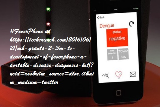 The proposal builds on the FeverPhone and NutriPhone platforms developed by the team at Cornell’s Institute for Nutritional Sciences, Global Health and Technology (INSiGHT). The technologies, funded by the NIH and the National Science Foundation, evaluate infections and nutritional status using blood. According to Mehta, technologies using salivary biomarkers could revolutionize how conditions such as malaria and iron deficiency are identified and addressed, especially in settings where access to primary health care and traditional, laboratory-based tests is limited.
Monsoon infections: How to tell the difference between dengue and malaria? Watch out for these symptoms
While both diseases are mosquito-borne and cause similar symptoms such as fever, joint/muscle pain, headaches, and fatigue, some differences between their symptoms can help you identify the specific infections. Unique symptoms of Malaria: Stomach problems such as vomiting, Diarrhoea, Dry cough, Shivering, Spleen enlargement Unique symptoms of Dengue: Pain behind the eyes, Swollen glands, Rashes
Asia &Elimination &Epidemiology &Mapping &Surveillance Bill Brieger | 19 Jul 2018
Pilot Mapping, Real Time Reporting and Responding in High Risk Malaria Areas of Viet Nam
 Viet Nam is among the Asia-Pacific countries focusing on eliminating malaria. Mapping helps target malaria interventions. Nguyen Xuan Thang and colleagues (James O’Donnell, Vashti Irani, Leanna Surrao, Ricardo Ataide, Josh Tram, An Le, Sara Canavati, Tran Thanh Duong, Tran Quoc Tuy, Gary Dahl, Gerard Kelly, Jack Richards, Ngo Duc Thang) presented their pilot mapping efforts at the Malaria World Congress in Melbourne recently and below share their experiences with us.
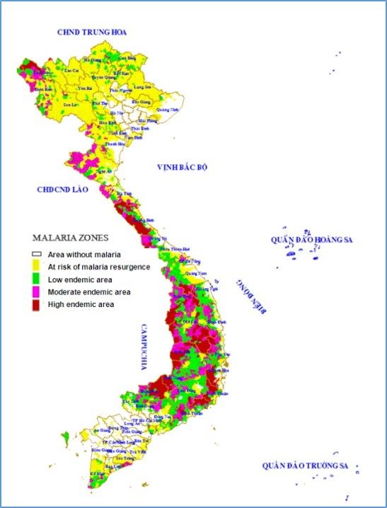
Viet Nam is focused on eliminating malaria by 2030. Viet Nam saw a 73% reduction in cases between 2013 and 2017 (NIMPE data), yet border provinces still have a high burden of malaria. However, some provinces still have a high burden of malaria. To achieve malaria elimination, it is essential to deploy targeted interventions in these locations.
 Spatial Decision Support Systems (SDSS) can be used by National Malaria programs to integrate geographic elements in the management of malaria cases and facilitate targeted malaria interventions in these high-risk settings.
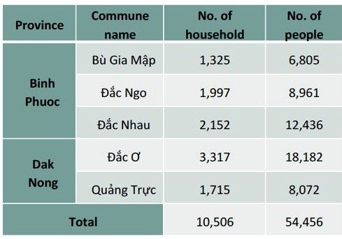
The objective of this work was to pilot a SDSS system for Binh Phuoc and Dak Nong Provinces in Viet Nam to facilitate ongoing surveillance and targeted malaria, as part of the Regional Artemisinin-resistance Initiative (RAI). This objective was achieved by:
-

Collecting data with cell phones
Collecting baseline GIS data at household level and environmental characteristics associated with the area;
- Establishing a routine data collection system that will be reported by mobile medical staff by mobile phone;
- Integrating this data to form a spatial decision support system (SDSS);
- Using the SDSS system for direct reporting to malaria control programs that provided strategic solutions for the prevention of disease spread and the elimination of malaria


Sample cell phone data screens
In Phase 1, a household and mapping survey was conducted in collaboration with commune, district and village health workers. Epicollect5 software was used on smartphones with GPS functionality to record mapping information (latitude and longitude) and general information on household members. During Phase 1, 10,506 households were surveyed and data was aggregated in a custom Geographic Information System (GIS) database.
 The majority of the surveyed individuals were of the Kinh ethnicity (19,282; 35.4%), followed by M’Nong (4,669; 8.6%) and Mong (3,359; 6.2%). Data related to malaria among mobile populations were included in the GIS as a means to identify and describe groups at high risk for malaria e.g. forest-goers. The survey data were reviewed, cleaned and matched using the ID numbers, then aggregated with relevant administrative boundary data and linked on ArcGIS 10.2 software. This database is located in a custom GIS system and can be visualized as a spatial transmission model to support appropriate decision-making

Dots representing households
Phase 2 focused on ongoing surveillance with rapid case reporting and responses. Malaria cases diagnosed at public and local health facilities were entered into the system by Commune Health Officials. Village Health Workers were immediately notified and went to the patient’s home to undertake case investigation including further household mapping and active case detection activities. The Viet Nam National Institute of Malariology was also notified, and organized local officials to carry out an investigation into the sources of transmission (i.e. ‘hotspots’) and to implement timely interventions.
Dots representing cases
When the cases were identified, Village Health Workers went to the patient’s home to undertake operational procedures including geographic exploration, household mapping to identify the location and to identify the list of affected households. They also collected this data on EpiCollect5. Collated information on cases, transmission point, zoning of the target villages allowed for early detection of malaria outbreaks. The National Institute of Malariology can also issue guidelines when the hotspots are identified and when disease outbreaks occur
 These activities are ongoing. In conclusion, a custom GIS database was developed using a household survey in Binh Phuoc and Dak Nong province of Viet Nam. Malaria cases were mapped to identify hotspots of malaria transmission and enable further active case detection and targeted interventions. This established GIS database aims to support routine case notification and to enhance the role of surveillance for active case detection and responses to achieve malaria elimination.
The authors are affiliated with the National Institute of Malariology, Parasitology, Entomology (NIMPE), Viet Nam; Burnet Institute, Australia; and Health Poverty Action, UK. Contact: xuanthang.nimpe@gmail.com
CHW &Community &ITNs &Ivermectin &Mapping &MDA &Seasonal Malaria Chemoprevention Bill Brieger | 04 Jul 2018
Mapping to Integrate Filariasis and Onchocerciasis Control with Malaria Interventions
 William R Brieger (wbriege1@jhu.edu) and Gilbert Burnham (gburnha1@jhu.edu) of The Johns Hopkins Bloomberg School of Public Health, Department of International Health presented ideas about mapping and integration of neglected tropical diseases and malaria interventions at the Malaria World Congress, Melbourne, Australia, July 2018
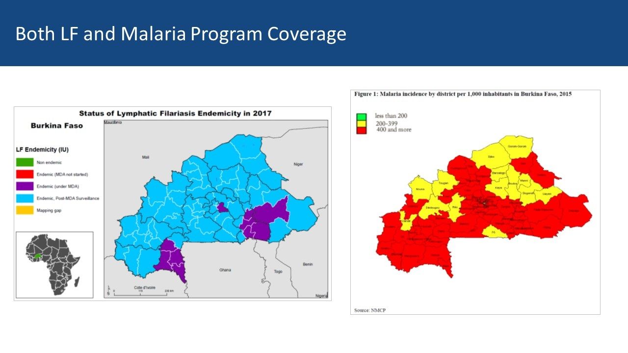
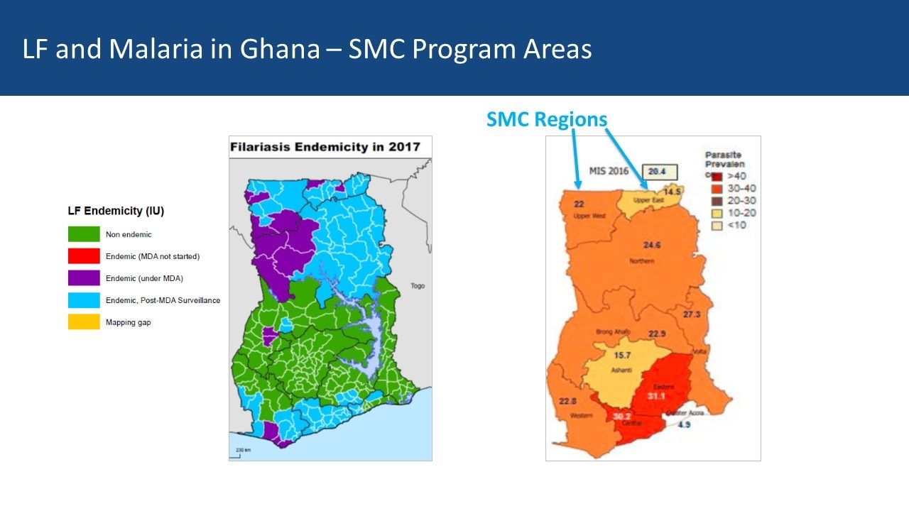
Overview: Lymphatic Filariasis (LF) and Malaria share a common vector in sub-Saharan Africa. Mass Drug Administration (MDA) is a strategy that is common to both diseases. Where the diseases overlap there is the potential opportunity to coordinate both vector control and MDA to achieve synergy in program results. The example of Burkina Faso, supplemented with information from Ghana, serves as an example of what could be integrated and what actually happens.
 Background: Thirty years ago then veterinary drug, ivermectin, was found effective in controlling neglected tropical diseases (NTDs), specifically two human filarial diseases: onchocerciasis and lymphatic filariasis (LF). The drug manufacturer donates 300 million treatments annually to eliminate both diseases. Since then, annual community based mass drug administration (MDA) efforts have resulted in millions of treatments in endemic countries and great progress has been made toward elimination of transmission. Through observation and experimentation, ivermectin was found to kill malaria carrying mosquitoes when they bite people who have taken ivermectin making it a useful tool for vector control.

CHWs in Burkina Faso demonstrating how to measure height to determine ivermectin dosage
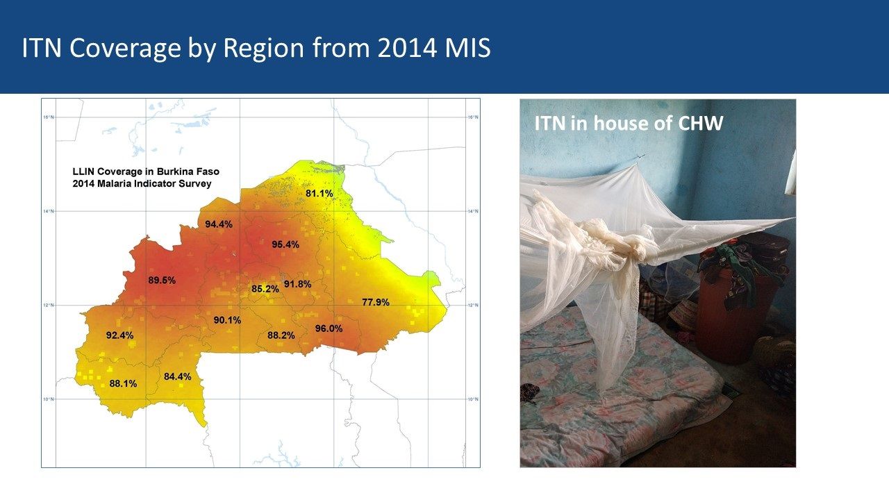
Community Health Workers’ Role: Current research is examining how dosing and timing of treatments may impact national malaria vector control efforts. Comparing maps between malaria and LF can be a starting point for adapting ivermectin MDAs for malaria vector control. Burkina Faso MDAs are operationalized by community health workers (CHWs) who are part of a national program that provides treatment for common illnesses and also conducts village level onchocerciasis and LF MDAs. Vector Control with Long Lasting Insecticide Treated Nets In most of rural Africa, malaria and lymphatic Filariasis are co-endemic and share the same anopheles mosquito vector.
However, that does not mean that there is a coordinated effort to plan distribution of LLINs despite the fact that the intervention meets the needs of both disease control efforts. The current NTD programs in Burkina Faso and Ghana focus on Preventive Chemotherapy (PCT) delivered through Mass Drug Administration (MDA). Vector Control is seen as essential in areas co-endemic with LF, Loa loa and Malaria – mapping helps identify priority areas for vector control.
 Vector Control by Chance: In Ghana, the NTD/LF elimination program was unaware of the LLIN coverage data available in the NMCP housed in an adjacent building. This illustrates the lack of collaboration between the two programs. Thus where — and if — vector control benefits the reduction of both diseases, it is often by chance where LF is concerned. The International NGO, The Carter Center, may be the only one that includes vector control as part of its programming for both malaria and LF in Nigeria. This practice should be replicated by other partners and country programs where possible.
 Mass Drug Administration: MDA is the major strategy for control of five PCT diseases in the NTD program, and LF is one of those. Currently MDA anti-malarial drugs has been considered in limited situations in countries where there are areas that have very low transmission In the future countries may consider research that shows mosquitocidal effects of Onchocerciasis and LF MDAs with ivermectin. Otherwise for malaria, a special intervention called Seasonal Malaria Chemoprevention (SMC) is used in an MDA-like approach to reach young children in the African Sahel during high transmission months. In both cases, existing cadres of (usually volunteer) community health workers are the front line providers of MDA.
Burkina Faso LF Map from ESPEN: Mapping shows 10 of 70 health districts are currently doing LF MDA, though all have done it. Thus CHWs in all districts are experienced in ivermectin MDA. The malaria map shows that two-thirds of districts have a malaria incidence of 400/1000 or more while 14 have lower incidence. There is an overlap between current LF MDA districts and higher incidence malaria districts Both LF and Malaria Program Coverage can be seen to overlap in [program maps.

Ghana CHWs explain how they conduct MDA
Ghana Experiences: Ghana provides a contrasting example. There five regions in central Ghana that are mostly non-endemic for LF but do have moderate malaria transmission In the south two regions with former LF MDA activity overlap with higher malaria endemicity While four northern regions have lower malaria parasite prevalence, they do have current and recent LF MDAs Community Directed Distributors work with LF MDA in Ghana
Conclusions: Malaria elimination will need a mix of strategies to be successful. Therefore, it is not too early for malaria and NTD program managers, as well as their respective donors, to begin comparing maps to identify possibilities for adapting ivermectin MDAs for malaria vector control. Even though one endemic disease is nearing control or elimination, the infrastructure put in place to accomplish this can be mobilized for other disease control efforts – as long as we map where interventions and resources have been targeted.
Borders &Mapping Bill Brieger | 01 Oct 2015
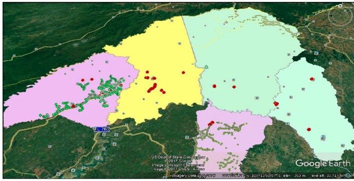
High Resolution Malaria Risk Mapping in Mutasa District, Zimbabwe: Implications for Regaining Control
Mufaro Kanyangarara and her PhD thesis adviser, Luke Mullany of the Johns Hopkins Bloomberg School of Public Health Department of International Health, have been looking into the challenges of controlling and ev entually eliminating malaria in a multi-country context in southern Africa. We are sharing abstracts from her pioneering work including the following which explores high resolution risk mapping in Zimbabwe near the Mozambique border.
Background: In Zimbabwe, more than half of malaria cases are concentrated in Manicaland province, where malaria continues to rebound despite intensified control strategies. The objectives of this study were to develop a prediction model based on high-resolution environmental risk factors and obtain seasonal malaria risk maps for Mutasa District, one of the worst affected districts in Manicaland Province.
Methods: Household RDT status was obtained from ongoing community-based surveys in Mutasa District from October 2012 through April 2015. While environmental variables were extracted from remote sensing data sources and linked to household RDT status. Logistic regression was used to model the probability of household positivity as a function of the environmental covariates. Model prediction performance and overall model fit were examined. Model predictions and prediction standard errors were generated and inverse distance weighting was used to generate smoothed maps of malaria risk and prediction uncertainty by season.
Results: Between October 2012 and April 2015, 398 households participated in the household surveys. Ninety-six individuals representing 66 households tested RDT positive. Household malaria risk was significantly higher among households sampled during the rainy season and further from the Mozambique border, while malaria risk was lower in sparsely populated areas as well as households located at higher elevations during the rainy season. The resulting maps predicted elevated risk during the rainy season particularly in low-lying areas bordering with Mozambique. In contrast, the risk of malaria was low across the study area during the dry season with foci of malaria scattered along the northern, western and south-eastern peripheries of the study area.
Conclusion: This study provides evidence for the significant heterogeneity of malaria, which was strongly linked to elevation, house density and proximity to the Mozambique border. These findings underscore the need for strong cross-border malaria control initiatives to complement country specific interventions.
Epidemiology &Mapping &water Bill Brieger | 23 May 2014
Satellite Mapping, an important step toward malaria control and elimination in Nigeria
Omede Ogu of Nigeria’s Federal Ministry of Health reports on efforts to undertake mapping of malaria in the country as a basis for better planning of control and eventual elimination efforts.
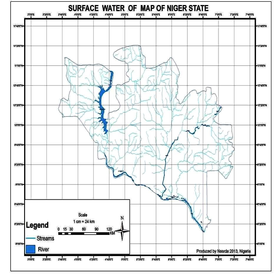 The National Malaria Elimination Program (NMEP) has been meeting with the team from the National Space Research and Development Agency (NASRDA). Progress on pilot malaria mapping in Niger State is being reviewed, though the study is yet to be concluded. NMEP is also looking at opportunities that exist to expand their initial mapping to cover the whole of the country. Discussions are underway on next steps and development of a road map or a framework for the study going forward.
NASRDA explained that the current mapping effort was aimed is to use satellite-based technology to map surface water for Malaria Control in North-central Nigeria with Niger State as a Pilot study. They noted that data in inaccessible locations such as the marshy areas, thick forests, rugged terrain etc. were previously unavailable for relevant environmental policy and decision making in the region and Nigeria.
In addition is will be possible to do infrastructural mapping and inventory of health care facilities, in order to identify and assess the state of health care facilities, how accessible and future areas of need provision of these facilities in the country.
So far NASRDA has identified settlements, and locations of hospitals and health centres throughout Niger State using Global Positioning System (GPS). They have also identified water bodies and wetlands locations throughout the state.
Finally they are developing a map of Surface Water and wetlands in the state showing these in relation to locations of settlements, hospitals and health centres. NMEP is planning to link with colleagues doing similar mapping in Kenya.
NMEP plans to have the final report of the study ready by October for dissemination. Major partners with funding lines in their 2014 work plans for this study are the National Primary Health Care Development Agency (NPHCDA) and NASRDA. Additional funding and support is being sought.
Kenya already is using its mapping to focus appropriate malaria interventions. All countries will benefit in better mapping for targeting their malaria control and elimination efforts.